Current caseService & transformation design

Selected work

Follow the Cairns.

Enter the project

Archive · team project, 2026. This is the original GSA MDes Stage 2 project as Team 06 presented it in May 2026. I later redesigned the cairns and their service on my own; that work is the current case.

See the 2026 redesign →

Low-carbon mobility · transformation design

About the project.

Leaving after dark should feel legible.
The habitat still needs darkness.
How little light is enough?

Context

MDes Stage 2 course project
The Glasgow School of Art · 2026

Role

Team lead in a five-person team
Service & system design

Outcome

Low-impact winter exit system
Concept, touchpoints and roadmap

Team project, developed with The Burrell Collection.
Tong Xu, Yiguo Xu, Yanting Zhang, Dongqiao Zhuang and Wu Yiyang. This case distinguishes our shared proposal from my contribution as team lead.

GSA project record ↗
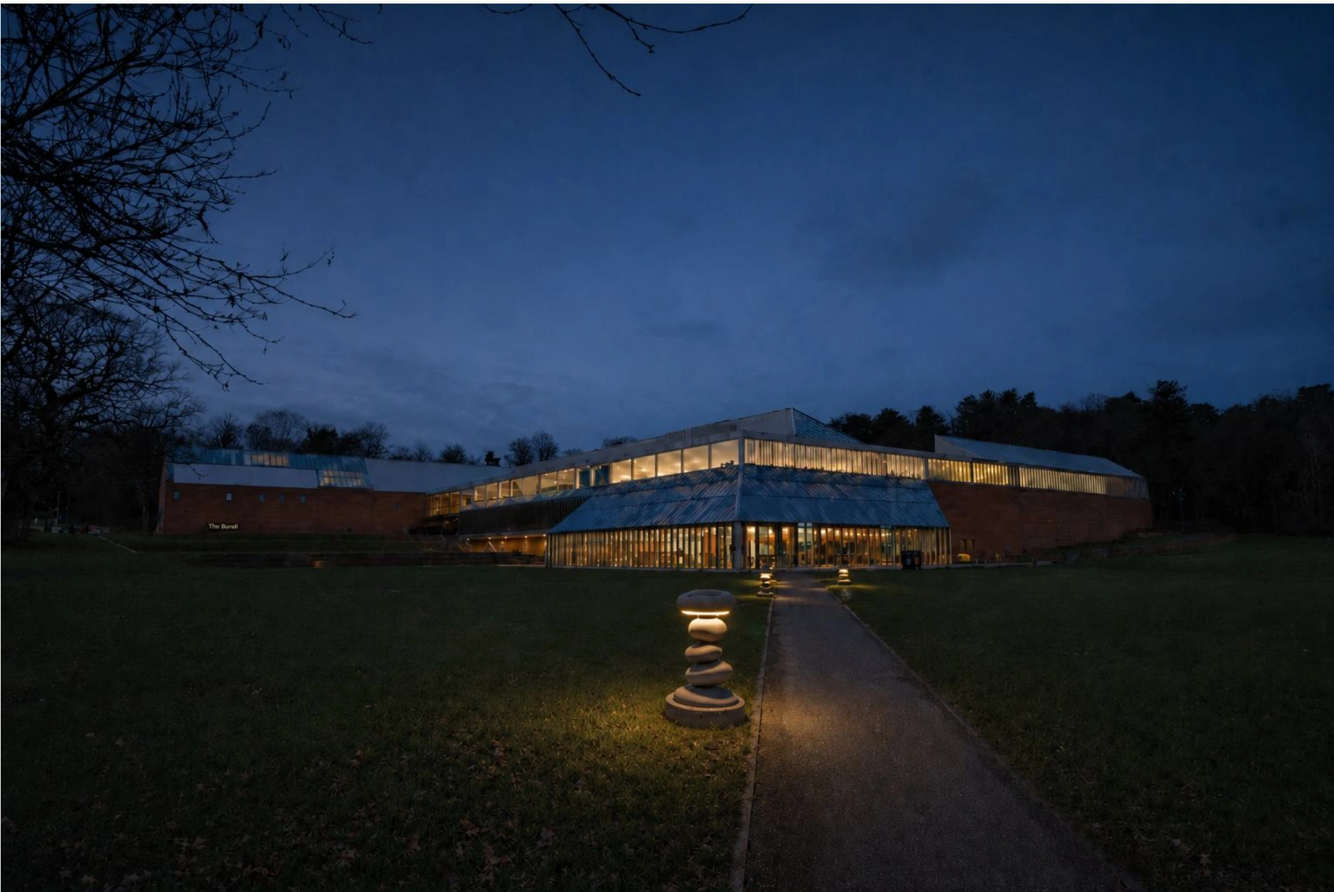
The Burrell Collection at dusk, with low cairn-shaped markers lit along the path leading away from the building
Safe exit in harmony with nature. Low markers give confirmation along the exit route instead of lighting the whole park. Visualisation over a site photograph.

The brief said reduce car use.
The site said something
more specific.

Pollok Country Park is both a visitor route and a living habitat. Adding light would help one and harm the other.

My first assumption was that low-carbon mobility meant persuading people out of their cars. That position did not survive contact with the site. Some visitors rely on a car because of age, disability, distance, caring responsibilities, weather or time — a project aimed at stopping car use would exclude exactly the people the brief asked us to consider.

So the target moved. Not who drives, but what conditions make driving feel like the only reliable option. In this park those conditions concentrate in one moment: leaving the museum after dark in winter, and deciding whether walking, the shuttle or onward transport still feels usable.
Three things partners told us
that we could not design past.

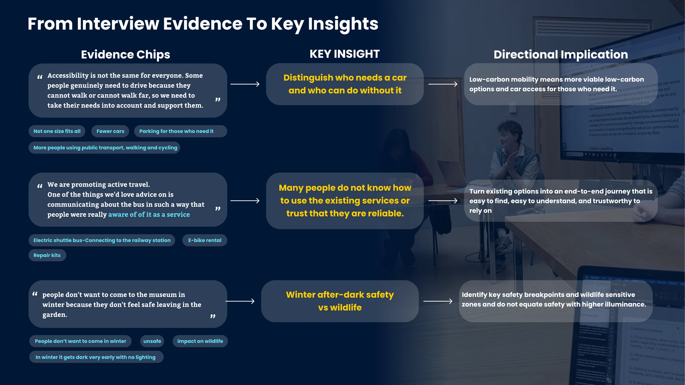
We worked from interview evidence to insight to a directional implication, so that each design move could be traced back to something someone actually said.

Team board mapping three interview quotes to three key insights and their directional implications: who needs a car, whether people know how to use existing services, and winter after-dark safety versus wildlife Opens the full-resolution board in a new tab
The team traced partner evidence into three directions: preserving access for people who need a car, making existing transport services easier to understand, and addressing winter departure confidence alongside ecological darkness.

The third insight was the one we chose, because it was the only one where the tension had two sides that could not both be satisfied by the obvious answer. Making people feel safe after dark points straight at more lighting. Protecting the park's nocturnal ecology points straight away from it.

We named that as the design site: after-dark safety versus wildlife disturbance — a specific time, a specific place, a human need and an ecological limit, all in the same fifteen minutes of someone's evening.

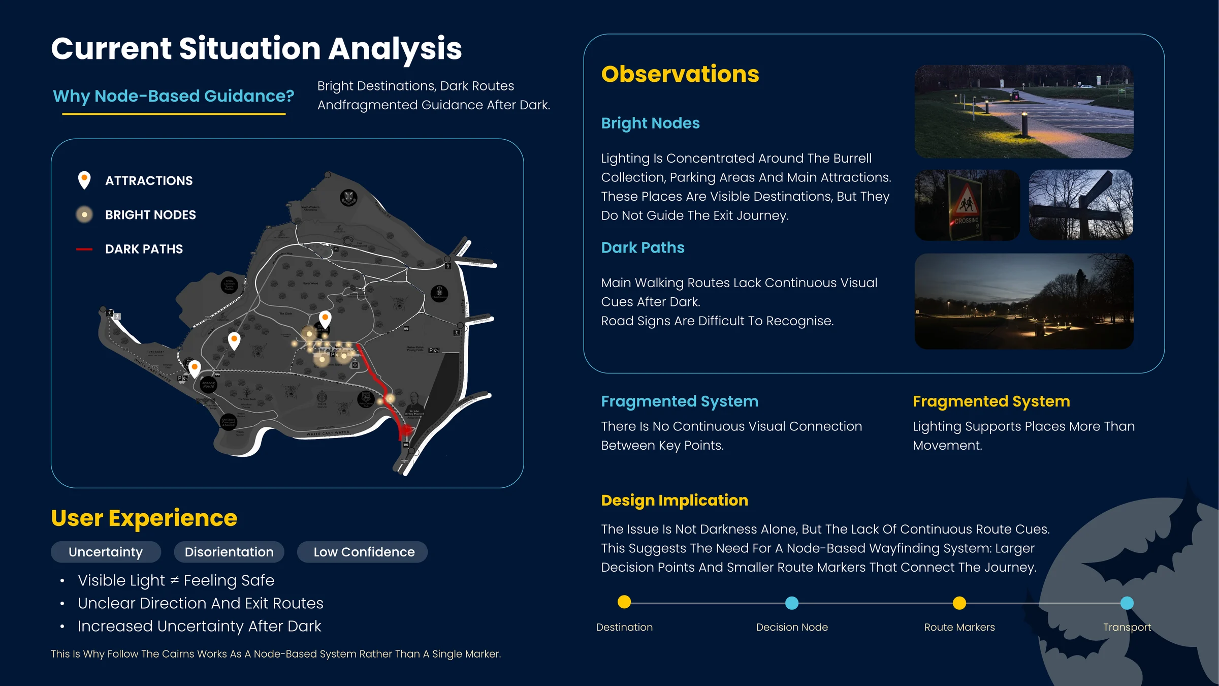
Site analysis · where route cues disappear
Team board analysing the current situation: a park map marking attractions, bright nodes and dark paths, night photographs of unlit routes and unreadable signage, and a design implication proposing node-based wayfinding Opens the full-resolution board in a new tab
Site observation reframed the problem again. Lighting in the park is concentrated on destinations — the museum, the car park — and the routes between them go dark. The conclusion was not “the park is too dark” but “the route has no continuous cues”: visible light did not equal feeling safe. That is what makes this a wayfinding problem with a node structure, not a lighting problem.

Darkness is not empty.
Something else
lives in it.

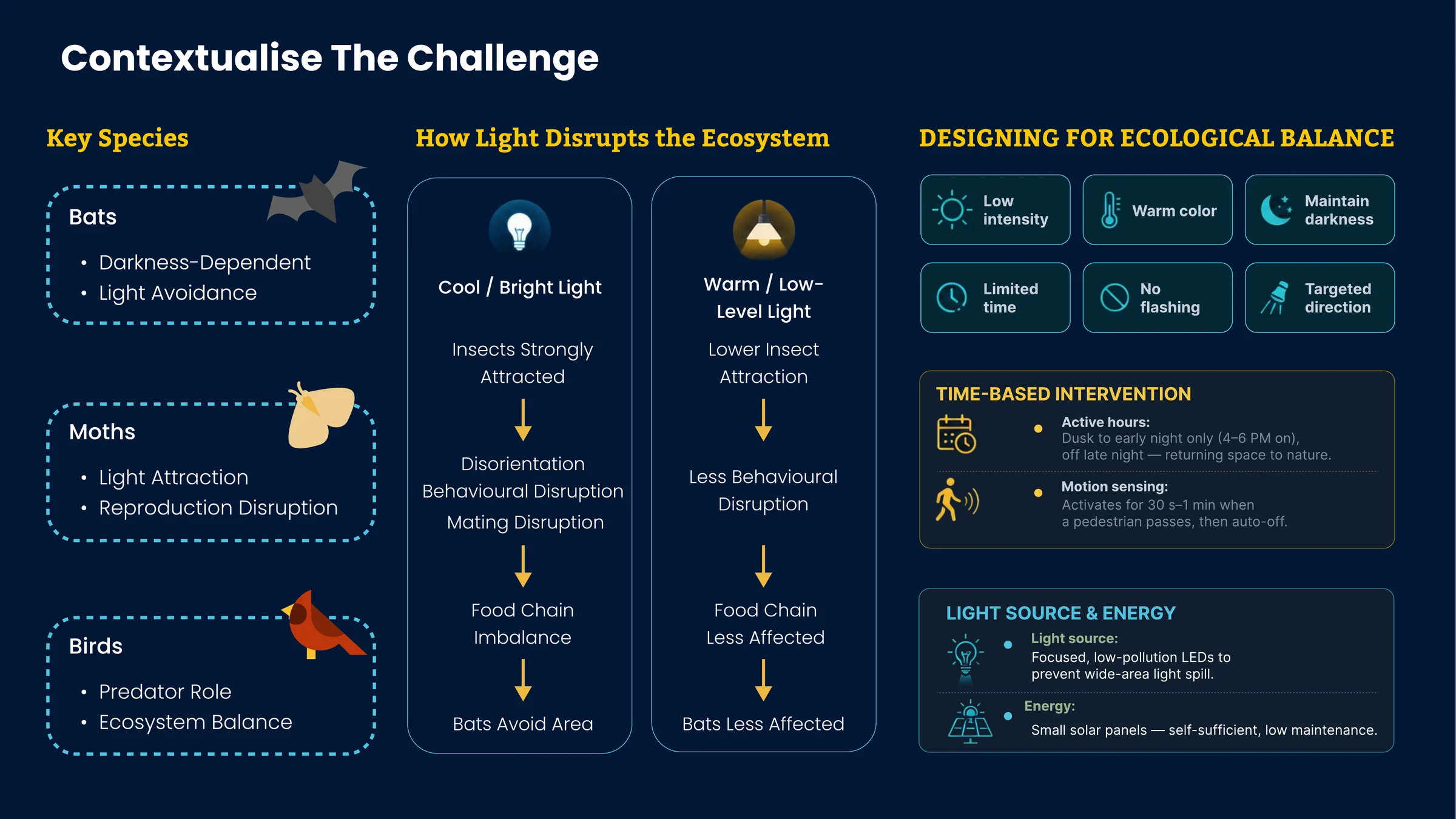
The team’s ecological research made darkness a design requirement, alongside visitor access.

We mapped potential effects of artificial light on insects, bats and birds. That research shaped a lower-impact design intention; it did not establish that the proposed system would be harmless to wildlife.

That chain is why the design is warm, low, targeted and time-limited rather than simply “eco-friendly”. It also gave us a framework to work inside — the DarkSky principles for responsible outdoor lighting: useful, targeted, low-level, controlled, warm-coloured.

Ecological research · why light is constrained
Team board on ecological balance: key species bats, moths and birds; two comparison chains showing how cool bright light versus warm low-level light affect insects, behaviour and the food chain; and six design principles for lighting Opens the full-resolution board in a new tab
The ecological argument, worked through rather than asserted. It produced two operational rules we could design against: active only from dusk to early night, with brief motion-triggered illumination. The final proposal specifies 90 seconds before fade — an intended reduction in disturbance that still needs ecological assessment.

The position we settled on

Design should not remove access for people who genuinely need a car. It should increase confidence and alternatives for the people who could shift but currently do not trust them.

Reassurance,
not illumination.

A cairn is a waymarker, but it also says someone came this way before. In a dark park that is a different message from a streetlight.

Our first concepts were all lighting: glowing wristbands, phone-torch modifiers, reflective vests, luminous stones. They answered the brief but treated safety as a visibility problem. Feedback after the interim presentation asked how stargazing groups move safely in dark environments without strong light sources — and that question moved the project from illumination to low-impact navigation.

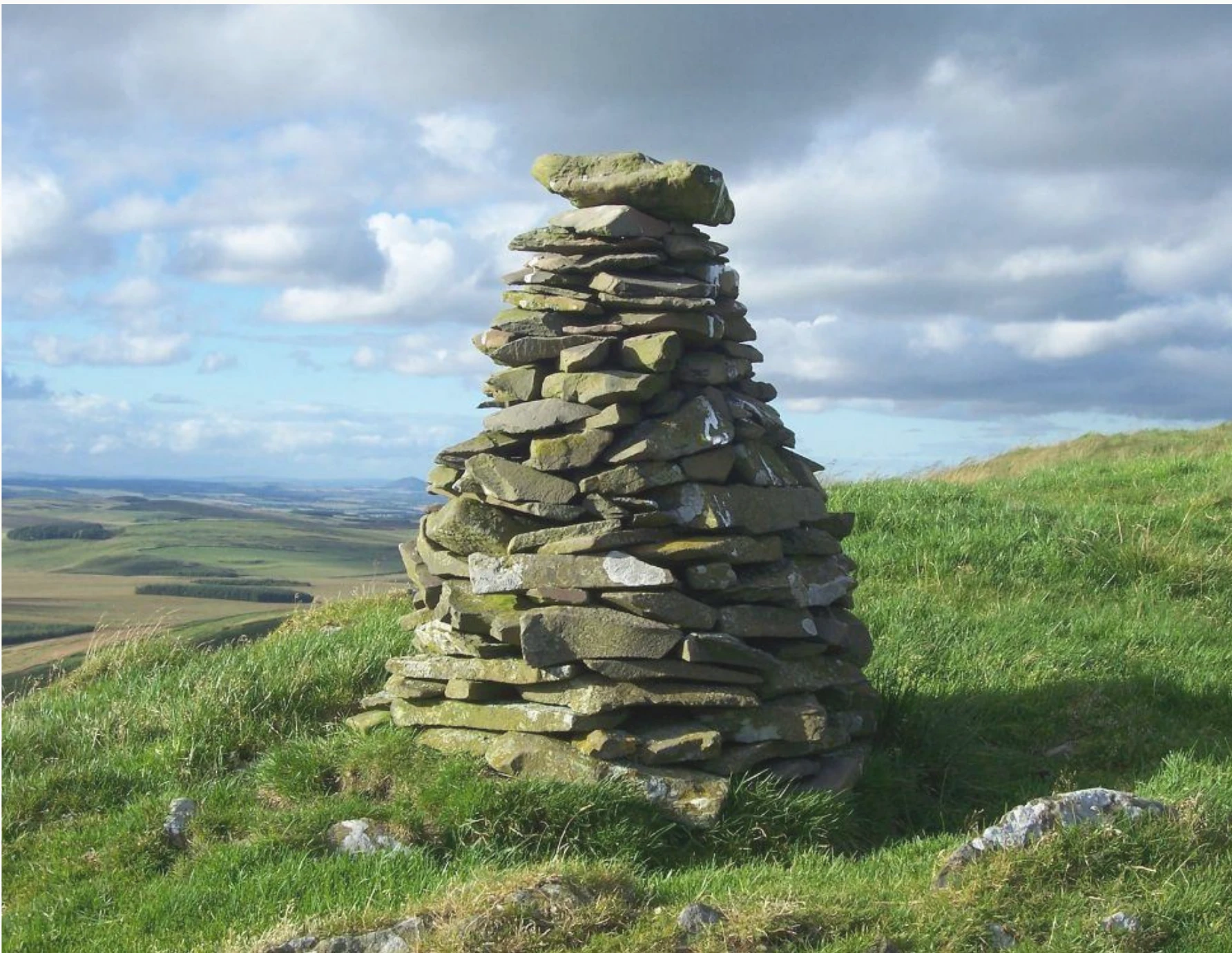
The cairn came from secondary research into Scottish landscape navigation. It could sit low, give confirmation rather than flood the path, and read as part of the park rather than as imported urban infrastructure.

A traditional dry-stone cairn standing on a grassy hillside under a cloudy sky
The reference. A cairn marks a route and signals that someone has passed through — direction and reassurance in the same object.
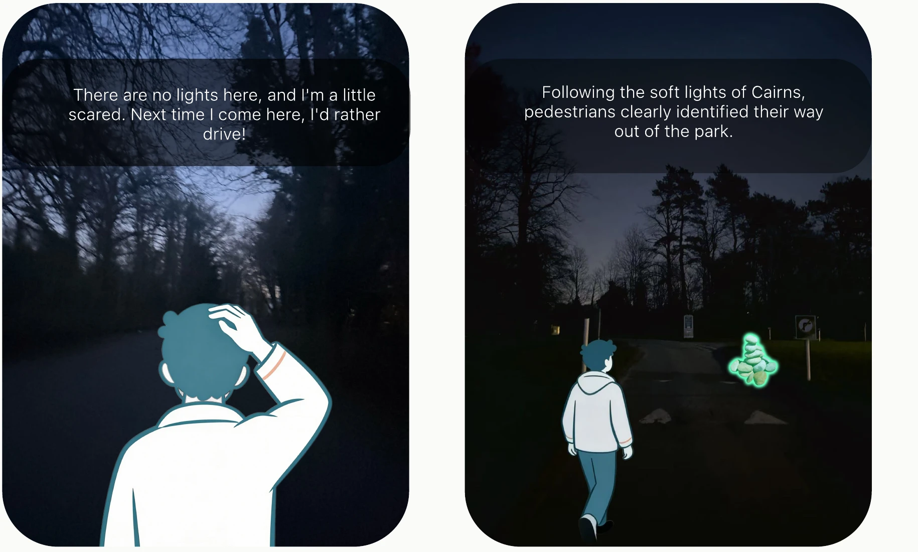
Two side-by-side night scenes of the same park path: in the first a figure hesitates in darkness, in the second a walker follows a softly lit cairn marker toward the exit
The moment the project is about. Left: the current experience. Right: the intended one. Illustrated scenarios over site photographs — not documentation of an installed system.
Placement comparison · why low markers
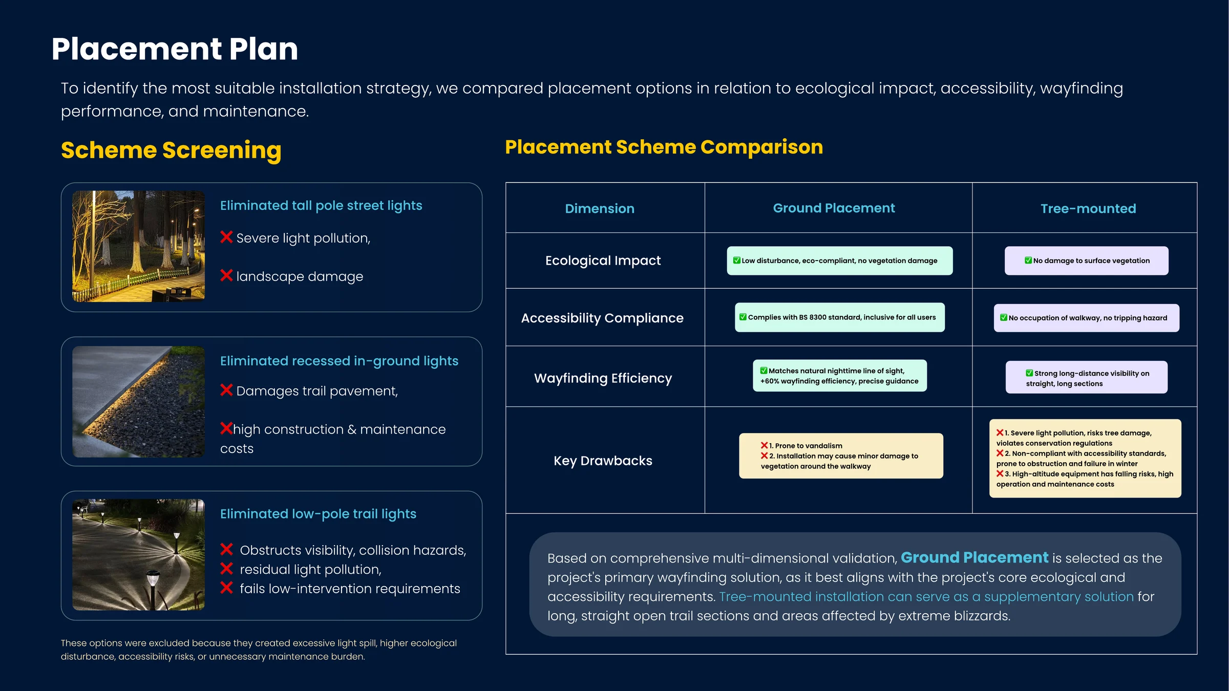
Team board comparing installation options: tall pole street lights, recessed in-ground lights and low-pole trail lights are eliminated, and ground placement is compared against tree-mounted across ecological impact, accessibility compliance, wayfinding efficiency and drawbacks Opens the full-resolution board in a new tab
Where the markers go was decided by elimination, not preference. Tall poles spill light and damage the landscape; recessed in-ground units damage the trail surface and cost too much to maintain; low-pole trail lights obstruct visibility. Ground placement won on ecological impact and on accessibility — the team intended to keep obstacles off the walkway. Accessibility compliance still requires specialist review and on-site testing.
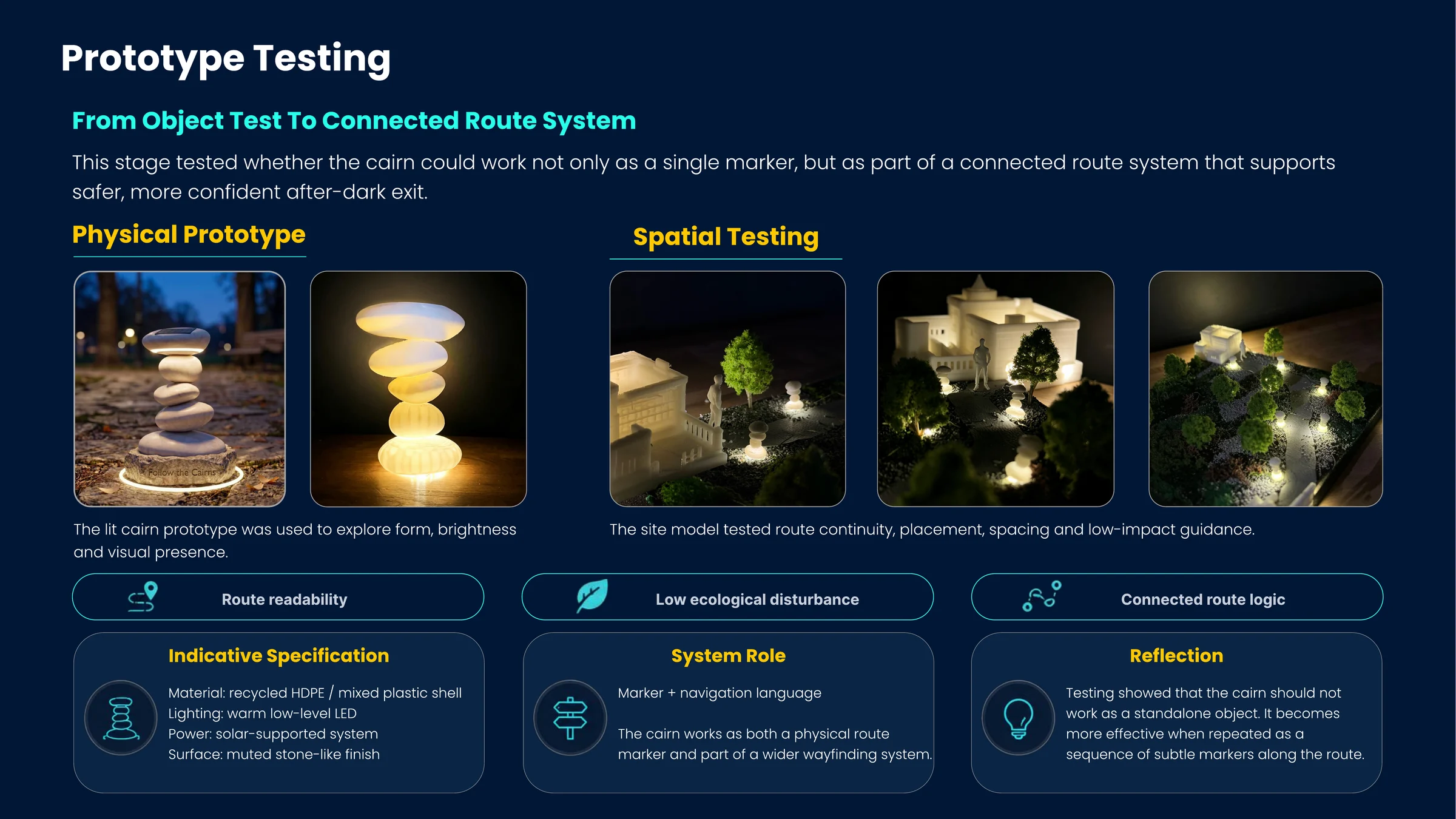
Team board on prototype testing: photographs of a lit cairn prototype outdoors and on a desk, and three night photographs of a site model with lit markers along a miniature path, alongside an indicative material specification Opens the full-resolution board in a new tab
Two prototypes answering two different questions. The lit object tested form, brightness and presence. The site model tested something the object alone could not: continuity, spacing, and whether a sequence of markers reads as a route. The finding was that a cairn should not work as a standalone object at all.

Should it stay on,
or come on when
someone walks past?

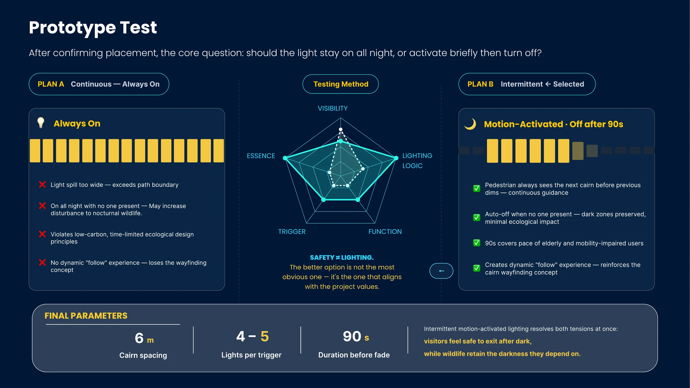
Always-on is the obvious answer, and it fails every value the project had committed to.

Continuous light spills past the path boundary, burns all night with nobody present, breaks the time-limited ecological principle, and — the part that surprised us — destroys the “follow” experience entirely. An always-lit route would also lose the sequential guidance we wanted to explore.

We selected intermittent, motion-activated lighting as a way to address both needs: the next marker would appear before the previous one dims, then the route would return to darkness. Whether that sequence offers enough reassurance for different walkers remains a question for field testing.

Explore the lighting decision

A little light.
A way forward.

For the people leaving.
For the life that stays.

Five nearby markers are lit; the rest of the route stays dark.

6 m
Proposed spacing
4–5
Lights per trigger
90 s
Proposed time before fade

An interactive illustration of the team’s proposal.
Concept geometry, not an installed or tested lighting system.

Original comparison · continuous versus triggered light
Team board comparing Plan A continuous always-on lighting against Plan B intermittent motion-activated lighting across visibility, lighting logic, function, trigger and essence, concluding with final parameters Opens the full-resolution board in a new tab
Plan A versus Plan B, scored on five dimensions. The resulting parameters are specific: markers every 6 metres, 4–5 lights illuminated per trigger, 90 seconds before fade — intended to accommodate different walking speeds while limiting illumination. These are proposed parameters, not validated accessibility or ecological outcomes.

The cairn was the entry point,
not the whole answer.

Pushing it from object to system was the part I argued for inside the team.

As a single marker it would still only fix one fragment of the journey, and the research had shown the failure was the departure sub-system as a whole: spatial legibility, service communication, perceived safety and ecological responsibility all failing at the same moment. So I proposed treating the cairn as a navigation language that could appear before the visit, at the museum exit, along the path, at the shuttle stop and in future shelters.

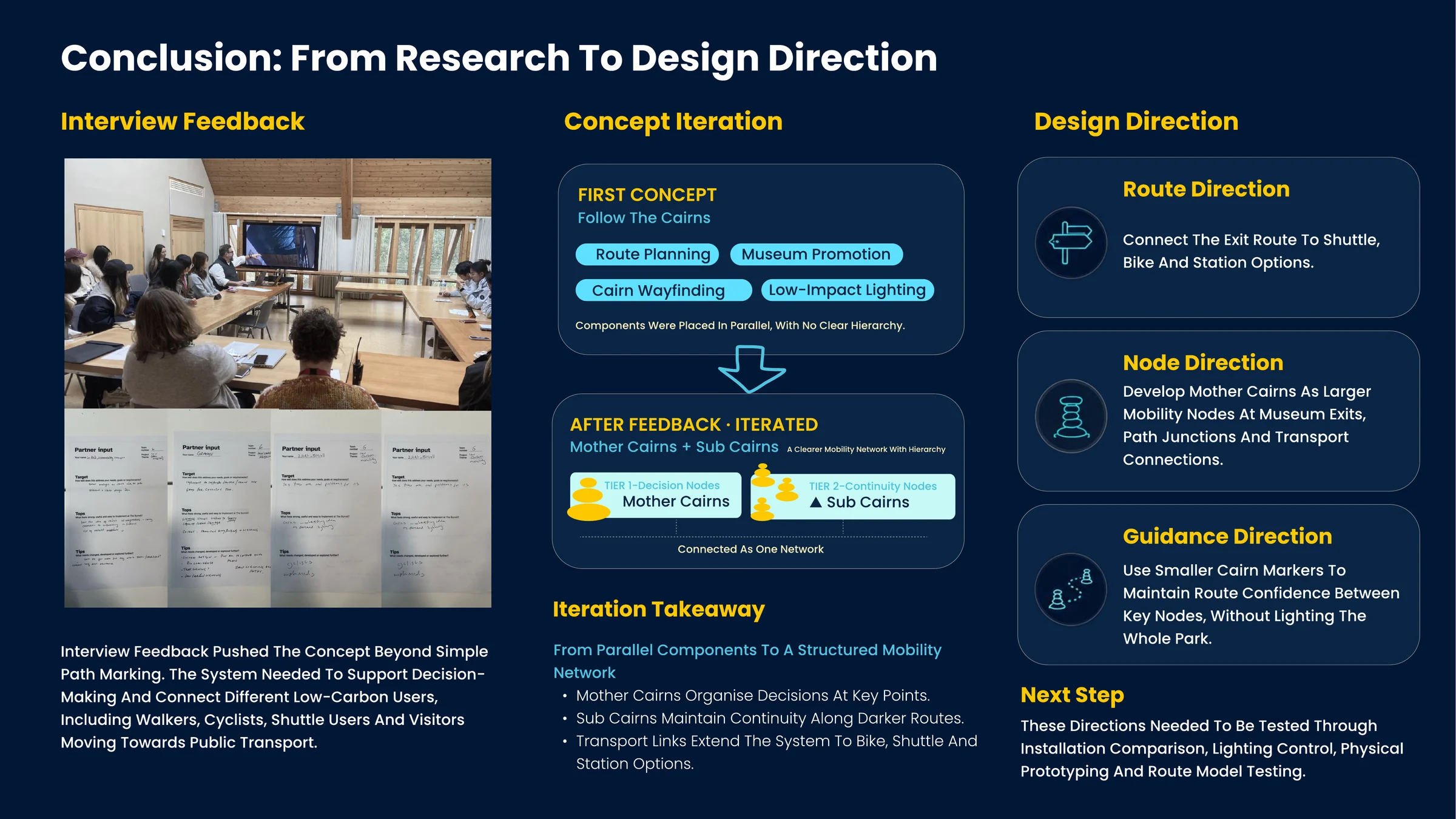
Partner feedback pushed in the same direction and gave the system its hierarchy: Mother Cairns as decision nodes at museum exits, path junctions and transport connections, and Sub Cairns as continuity nodes that hold route confidence in between. That distinction is what turned a set of parallel components into a network.

Partner feedback · from objects to a network
Team board showing interview feedback photographs and partner input sheets, the concept iteration from four parallel components to a two-tier structure of Mother Cairns and Sub Cairns, and three resulting design directions Opens the full-resolution board in a new tab
Before: route planning, museum promotion, cairn wayfinding and low-impact lighting sat in parallel with no hierarchy. After: two tiers, one network. Feedback did not add features — it told us the features we had needed an order.
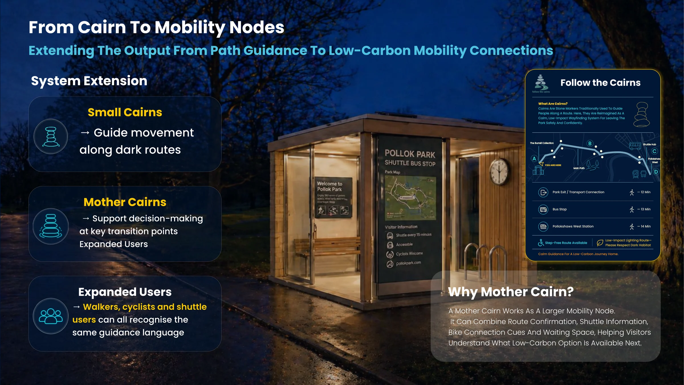
Team board showing a night render of a lit Mother Cairn shuttle shelter with park map and visitor information, alongside the Follow the Cairns wayfinding board listing walking times to the park exit, bus stop and Pollokshaws West station Opens the full-resolution board in a new tab
A Mother Cairn at its largest: shelter, route confirmation, shuttle information and bike connection in one place. The board beside it names destinations and their walking times, states that a step-free route exists, and asks visitors to respect dark habitat — the ecological constraint written into the visitor-facing artefact rather than hidden in the rationale.
Service journey · the complete departure flow
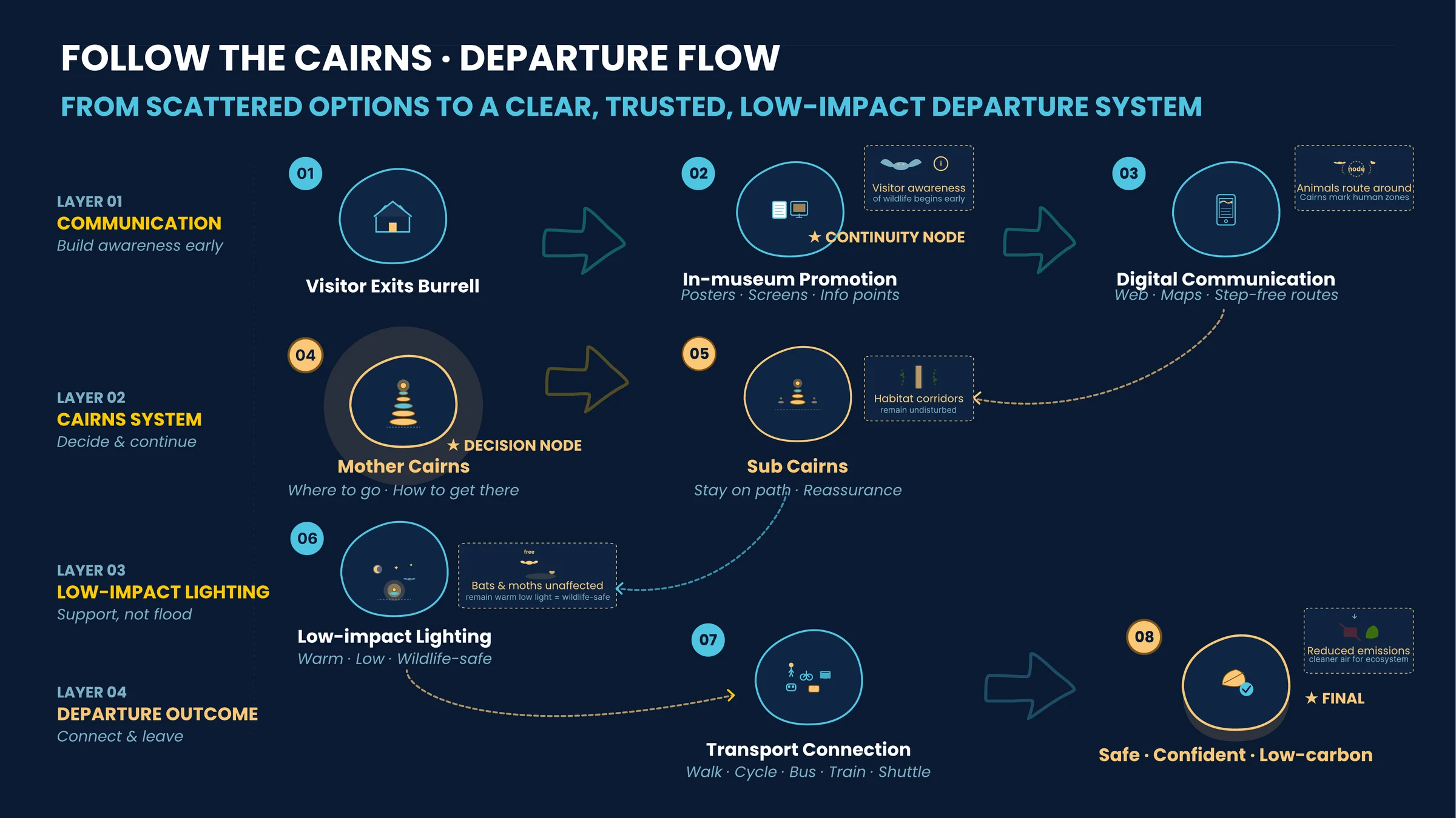
Team board showing the departure flow in four layers: communication, cairns system, low-impact lighting and departure outcome, running through eight steps from exiting the Burrell to a safe, confident, low-carbon journey Opens the full-resolution board in a new tab
The whole system as one journey. Communication starts before departure, the cairn network carries the decision and the continuity, lighting supports rather than floods, and the outcome is a transport connection the visitor trusts. Each layer notes what it means for wildlife, not only for people.
Roadmap · a phased proposal towards 2031
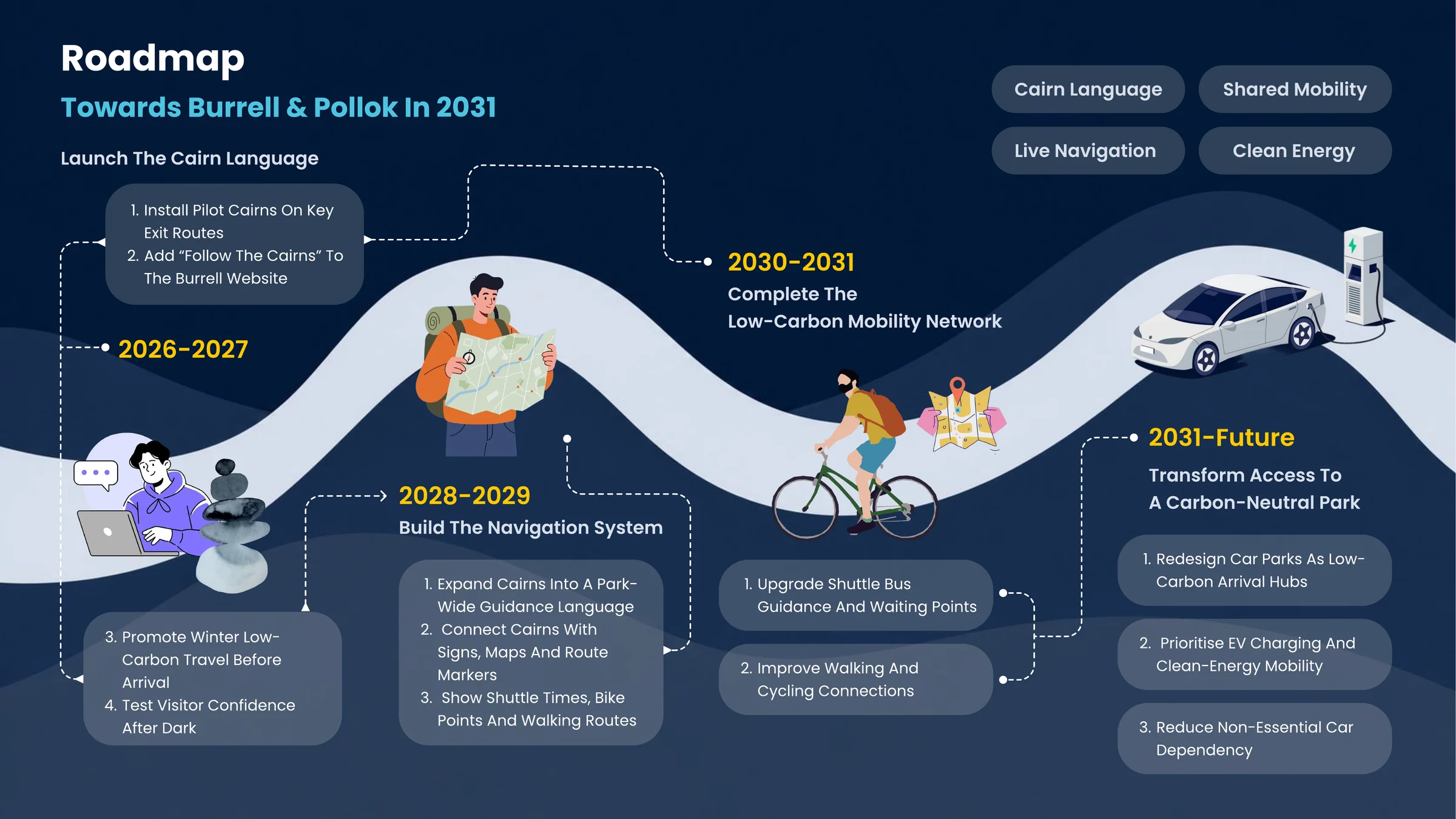
Team board showing a roadmap towards Burrell and Pollok in 2031 in three stages: launch the cairn language, build the navigation system, and transform access to a carbon-neutral park Opens the full-resolution board in a new tab
The proposal is written as a change pathway, not a product launch. Stage one installs pilot markers and pre-trip communication; stage two connects cairns to signs, shuttle times and bike points; stage three rethinks the car parks themselves. Each stage depends on agreement with The Burrell, NRS and Glasgow City Council.

A small marker.
A wider question.

The proposal does not remove car dependency. It addresses one condition that reinforces it.

This is a concept and system proposal, not an implemented system. The prototypes made the idea discussable and gave us parameters; they did not test night visibility with real visitors, wildlife response, weathering, maintenance or installation. Solar power may be unreliable in a Glasgow winter. Low-level markers may not be sufficient for older, disabled or visually impaired visitors — further testing would need to ask not whether the cairns look clear, but whether different visitors can recognise, follow and trust them.

The proposal also uses artificial light, so it cannot be called impact-free. What it does is refuse the most obvious infrastructure response — lighting the whole park — and treat darkness as something to work with. The clearest thing I take from it: mapping a system and deciding where to intervene are two different skills, and the second one is the harder of the two.

← Back to selected work Follow the Cairns · Team 06 · 2026 · The redesign →

Find your next question.

Back to selected work Objects, services & systems.

Trace the Line · Sheet A

Locate the involvement.

Place tokens where AI entered a real design process. The tokens mark perceived involvement, not a score.

Original Sheet A: Locate the involvement.

Where would you place it?

Drag a token, or choose a place below. Use all, some or none.

Try a placement. There is no correct answer, and this is not a score.

Reading this sheet

A real project anchors the conversation. Seven stages run from research to communication. Place tokens on or between stages to mark where AI felt involved, then choose the stage you thought longest about.

Open original image ↗ (opens in a new tab)